Sunday, April 17, 2011

Lab 3: Laker's Route to Championship 17


View Lakers route to Championship #17 in a larger map


Road Map of the Laker's path to the championship!


Neogeography has become a huge factor in the development of maps, and especially maps in the Web 2.0. It has allowed people to “check in” to nearly anywhere that has internet access or cell phone service. This has caused the world to be connected and an increase in spatial communication. It allows everyone to put their ideas out there for everyone to learn from. Neogeography can be seen as a collage, in which every small picture, or user-created map, is an integral part of the whole product. Without everyone contributing to it, neogeography would not be where it is today, it is powered by the individuals. By neogeography being interactive, it sparks interest in the young minds to contribute, and gets them involved with this movement and allowing for the rapid expansion of the field. I could see there being a heavy use and dependency on websites with databases of mash-ups in the near future.

However, since neogeography is based on user input, there is no real way that the maps can be cross checked for accuracy. This could cause for the spread of misinformation and misunderstanding, similar to encyclopedic websites that take posts from users and present them as information for the web to see (Wikipedia). 


Sunday, April 10, 2011

Lab 2


1.   Beverly Hills Quadrangle
2. Quadrangles
a.       NW - Canoga park
b.      W – Topanga
c.       SW – Pacific Ocean
d.      S – Venice
e.      NE – Burbank
3. 1966
4. Datum
a.       Horizontal – NAD 27
b.      Vertical – National Geodetic Vertical Datum of 1929
5. 1:24,000
6. Scaling
a.       5/100*24000 = 1,200 m
b.      120000/12/5280 = 1.894 mi.
c.       1*5280*12/2400 = 2.64 in.
d.      3*1000*100/24000 = 12.5 cm.
7.    20 feet
8.        Coordinates
a.       Public Affairs
 i.      Latitude à 118 degrees 26 minutes 6 seconds (118.4343)
 ii.      Longitude à 34 degrees 4 minutes 30 seconds (34.071)
b.      Santa Monica Pier
 i.      Latitude à118 degrees, 29 minutes, 55 seconds (118.575)
 ii.      Longitude à 34 degrees, 0 minutes, 20 seconds (34.0033)
c.        Upper Franklin Canyon Res.
 i.       Latitude à118 degrees 24 minutes 30 seconds (118.405)
 ii.      Longitude à34 degrees 7 minutes 5 seconds (34.1175)
9.        Elevation
a.       Greystone mansion à 560 ft, 169.7 meters
b.      Woodlawn cemetery à 140ft., 42.4 meters
c.       Crestwood hills park à800 ft, 242.4 meters
10.   11
11.   63 Northing, 361.5 Easting
12.   1 km2
13.    


14.   +14 degrees
15.   Southward flow
16. Map of UCLA

Thursday, March 31, 2011

The Most Interesting Maps in the World

http://www.plumberorangecountytanklesswaterheaterslableakrepairpipessewer.com
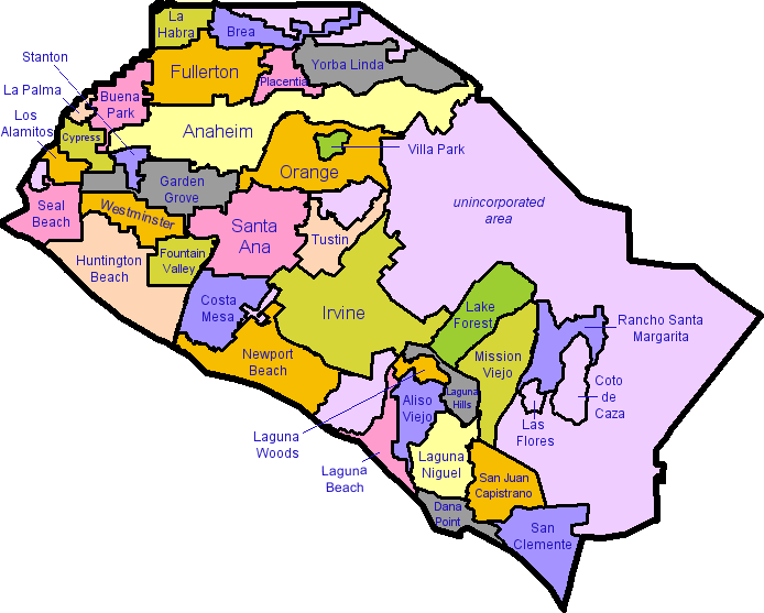
This map was from a plumber's website, and it seems that it is used to show that they work everywhere in Orange County. The map shows all the cities in Orange County and shades each city with a different color.  I find this map interesting because I am from Orange County and never really looked closely at a map of my home area before. I chose this map in particular because it is easy to read, and shows only what I am looking for. For example, there were other maps of Orange County that I found which included freeways, rivers, and landmarks, but I was only interested in the boundaries and names of the cities so I chose this one.

http://www.new-york-city-map.com/manhattan.htm


This map to the right is of the Manhattan burrow of New York City. It was taken from a New York map website, and shows all the streets in the crowded region as well as the main landmarks and neighborhoods. I chose this map because I visited New York City last spring break and was fascinated by the layout of the city, and this map did a great job of showing the intricate complexities of Manhattan. It's really interesting to see how all the streets line up and the extreme organization and planning that was needed to design Manhattan's transportation system.

http://www.picturesdepot.com/places/19612/disneyland+map.html
This image was taken from a website with archives of pictures, and this map shows the different areas inside of Disneyland. I chose this map because I grew up about fifteen minutes away from Disneyland and used to visit it multiple times a summer with my grandparents. Looking on this map now, I see how structured it is, and as a small boy I never knew where I was; I would just follow my grandparents and older brother around. I like how the map is drawn, and not an actual image that is to scale.  It gives it a friendly feeling, after all, it IS the happiest place on earth...